The SCORP process collects and updates a lot of data every five years. This page seeks to make that data available for public use. As this one-year study progressed, data resources have been aggregated and an interactive means of accessing this data is provided through this web page.
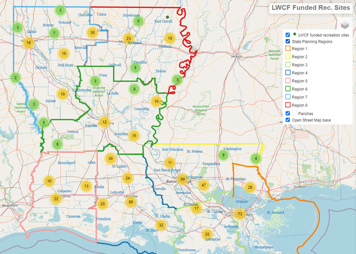
LWCF Funded Recreation Sites
The federal government through the Land and Water Conservation Fund program has provided funding assistance to state and local agencies for outdoor recreation sites. Over 735 sites across Louisiana are mapped and displayed via this interactive map. Click the image below to launch and explore this information.
LORI
Louisiana’s Outdoor Recreation Inventory (LORI) will be a collection of online tools and data sets available for public use. Presently, geographic data from the 2020 SCORP process is still being processed and aggregated for digital publication. The above map provides an example of the features yet to come. New data layers in progress include federal and state lands, and parks or facilities provided by parish, municipal or recreation district agencies.
Submit A New Recreation Site
Do you have a publicly accessible outdoor recreation site or facility that you do not see on our map? Submit basic information about the site using this form, we’ll compare it to our existing inventory and will then contact with you for additional details about the site.
More Resources
Below are links to additional online resources pertaining to outdoor recreation in Louisiana.
- Louisiana State Parks new website: www.lastateparks.com
- Louisiana Travel by the Department of Culture, Recreation and Tourism. It too has a State Parks page at www.louisianatravel.com/state-parks
- USDA Forest Service, National Forests in Louisiana: Kisatchie
- US Fish & Wildlife Services, National Wildlife Refuges 23 in Louisiana
- Discover the Forest (a 3rd party site): discovertheforest.org
- Recreation.gov